
North East Land topographic map
Interactive map
Click on the map to display elevation.
About this map
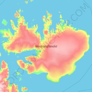
Name: North East Land topographic map, elevation, terrain.
Location: North East Land, Svalbard, Norway (79.20989 17.71146 80.50793 27.23729)
Average elevation: 156 m
Minimum elevation: -3 m
Maximum elevation: 1,172 m
Other topographic maps
Click on a map to view its topography, its elevation and its terrain.
Norway
Norway > Hamningberg > Apalen
Norway, 8100, Hamningberg, Båtsfjord, Troms og Finnmark, Norway
Average elevation: 143 m
Vetle Skagastølstind
Vetle Skagastølstind, Luster, Sogn og Fjordane, Norway
Average elevation: 1,783 m
Jesus Lever-steinen
Jesus Lever-steinen, Løvstien, Solheims Boretslag, Solheim, Årstad, Gyldenpris, Bergen, Hordaland, 5057, Norway
Average elevation: 100 m