
Thank you for supporting this site ❤️
Make a donation
Make a donation
Arc 1600 topographic map
Click on the map to display elevation.
Thank you for supporting this site ❤️
Make a donation
Make a donation
About this map
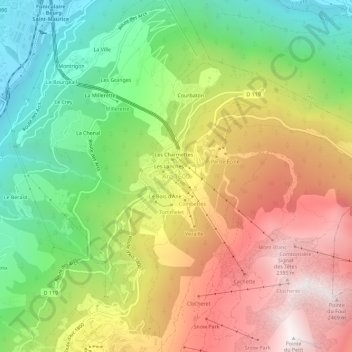
Name: Arc 1600 topographic map, elevation, terrain.
Average elevation: 1,560 m
Minimum elevation: 785 m
Maximum elevation: 2,476 m
Thank you for supporting this site ❤️
Make a donation
Make a donation
Other topographic maps
Click on a map to view its topography, its elevation and its terrain.
Charmettoger
France > Auvergne-Rhône-Alpes > Savoie > Bourg-Saint-Maurice > Arc 1800
Average elevation: 1,693 m
Fort de la Platte
France > Auvergne-Rhône-Alpes > Savoie > Bourg-Saint-Maurice > Les Échines Dessous
Average elevation: 1,773 m
Le Chantel
France > Auvergne-Rhône-Alpes > Savoie > Bourg-Saint-Maurice > Arc 1800
Average elevation: 1,775 m
Thank you for supporting this site ❤️
Make a donation
Make a donation
Le Charvet
France > Auvergne-Rhône-Alpes > Savoie > Bourg-Saint-Maurice > Arc 1800
Average elevation: 1,651 m