
Thank you for supporting this site ❤️
Make a donation
Make a donation
Jalukie topographic map
Click on the map to display elevation.
Thank you for supporting this site ❤️
Make a donation
Make a donation
About this map
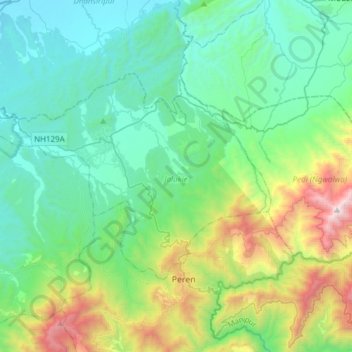
Name: Jalukie topographic map, elevation, terrain.
Location: Jalukie, Peren District, Nagaland, India (25.54058 93.50648 25.70174 93.81071)
Average elevation: 684 m
Minimum elevation: 170 m
Maximum elevation: 2,453 m
Thank you for supporting this site ❤️
Make a donation
Make a donation
Other topographic maps
Click on a map to view its topography, its elevation and its terrain.