
Chesapeake topographic map
Interactive map
Click on the map to display elevation.
About this map
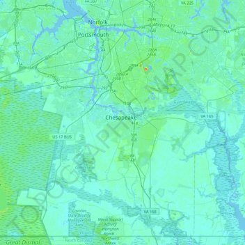
Name: Chesapeake topographic map, elevation, terrain.
Location: Chesapeake, Virginia, United States (36.55044 -76.49140 36.86718 -76.06520)
Average elevation: 5 m
Minimum elevation: -7 m
Maximum elevation: 42 m
Other topographic maps
Click on a map to view its topography, its elevation and its terrain.