
Thank you for supporting this site ❤️
Make a donation
Make a donation
Leeds topographic map
Click on the map to display elevation.
Thank you for supporting this site ❤️
Make a donation
Make a donation
About this map
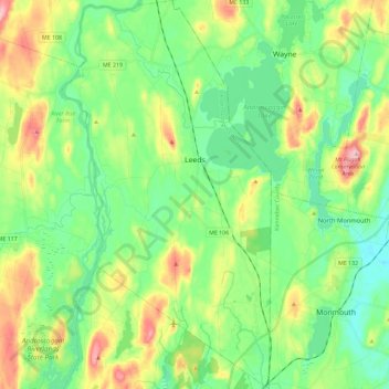
Name: Leeds topographic map, elevation, terrain.
Location: Leeds, Androscoggin County, Maine, 04263, United States (44.20618 -70.19883 44.37139 -70.07426)
Average elevation: 108 m
Minimum elevation: 47 m
Maximum elevation: 236 m
Thank you for supporting this site ❤️
Make a donation
Make a donation
Other topographic maps
Click on a map to view its topography, its elevation and its terrain.