
Thank you for supporting this site ❤️
Make a donation
Make a donation
Crediton topographic map
Click on the map to display elevation.
Thank you for supporting this site ❤️
Make a donation
Make a donation
About this map
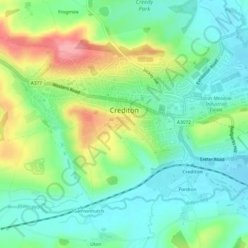
Name: Crediton topographic map, elevation, terrain.
Location: Crediton, Mid Devon, Devon, England, United Kingdom (50.77753 -3.67628 50.79845 -3.63192)
Average elevation: 72 m
Minimum elevation: 36 m
Maximum elevation: 142 m
Thank you for supporting this site ❤️
Make a donation
Make a donation
Other topographic maps
Click on a map to view its topography, its elevation and its terrain.
Wordland Cross
United Kingdom > England > Devon > Mid Devon > Cheriton Fitzpaine
Average elevation: 120 m
Thank you for supporting this site ❤️
Make a donation
Make a donation
Moor Copse
United Kingdom > England > Devon > Mid Devon > Oakford Bridge > Stoodleigh
Average elevation: 176 m
Thank you for supporting this site ❤️
Make a donation
Make a donation
Thank you for supporting this site ❤️
Make a donation
Make a donation
Thank you for supporting this site ❤️
Make a donation
Make a donation
Thank you for supporting this site ❤️
Make a donation
Make a donation
Brandside Corner
United Kingdom > England > Devon > Mid Devon > Yeoford > Neopardy
Average elevation: 92 m
Thank you for supporting this site ❤️
Make a donation
Make a donation