
Castalla topographic map
Click on the map to display elevation.
Castalla
Castalla Castle sits on a hill overlooking the valley and the town is around, at the foot of the hill, 680 m above sea level. Castalla La Hoya, whose history is Castalla capital, is a broad valley in the form of T oriented to the southeast and sandwiched between various mountain formations. Castalla occupies the west and southwest of La Hoya which interlock like Maigmó mountains (1296 m), Cati (1260 m) or Argenya (1230 m). The climate of the area can be locked in a mid-mountain Mediterranean climate. The average annual temperature is around 17 degrees. The rains are not abundant, around 400mm per year, but mountain ranges favor the formation of cloudiness and local rainfall, increasing these with altitude. Snowfall is common in winter days of January and February. Communicates with Alicante and Valencia along the A-7.
About this map
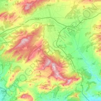
Name: Castalla topographic map, elevation, terrain.
Average elevation: 731 m
Minimum elevation: 362 m
Maximum elevation: 1,264 m
Other topographic maps
Click on a map to view its topography, its elevation and its terrain.
Cap de la Nau
Spain > Valencian Community > Xàbia / Jávea
Atop the headland, at an elevation of 120 metres (390 ft), stands the Cap de la Nau lighthouse, providing an important aid to navigation.
Average elevation: 32 m
Playa Flamenca I
Spain > Valencian Community > el Baix Segura / La Vega Baja del Segura > Orihuela > Urbanización La Zenia
Average elevation: 25 m
la Garrotxa
Spain > Valencian Community > Castelló / Castellón > Cervera del Maestre
Average elevation: 273 m
La Mata
Spain > Valencian Community > el Baix Segura / La Vega Baja > Torrevieja
Average elevation: 5 m
Platja del Cabanyal - Les Arenes
Spain > Valencian Community > Comarca de València > Valencia
Average elevation: 2 m
La Mata
Spain > Valencian Community > el Baix Segura / La Vega Baja > Torrevieja
Average elevation: 5 m
Urbanización Doña Pepa
Spain > Valencian Community > el Baix Segura / La Vega Baja del Segura > Rojales
Average elevation: 24 m
Raiguero de Bonanza
Spain > Valencian Community > el Baix Segura / La Vega Baja > Orihuela
Average elevation: 139 m
Castell de Benissili
Spain > Valencian Community > la Vall de Gallinera > Benissili
Average elevation: 629 m
Coma Breco
Spain > Valencian Community > el Poble Nou de Benitatxell / Benitachell
Average elevation: 147 m
Torre de la Horadada
Spain > Valencian Community > el Baix Segura / La Vega Baja del Segura > Pilar de la Horadada
Average elevation: 5 m
Balsa de riego goteo Pozo la Esperanza
Spain > Valencian Community > Nàquera / Náquera
Average elevation: 92 m
Castell de Benissili
Spain > Valencian Community > la Vall de Gallinera > Benissili
Average elevation: 629 m
Dehesa de Campoamor
Spain > Valencian Community > el Baix Segura / La Vega Baja del Segura > Orihuela
Average elevation: 28 m
Cabo Roig
Spain > Valencian Community > el Baix Segura / La Vega Baja del Segura > Orihuela
Average elevation: 9 m