
Thank you for supporting this site ❤️
Make a donation
Make a donation
Clungunford topographic map
Click on the map to display elevation.
Thank you for supporting this site ❤️
Make a donation
Make a donation
Clungunford
Clungunford lies at an elevation of between 130m and 145m above sea level.
Thank you for supporting this site ❤️
Make a donation
Make a donation
About this map
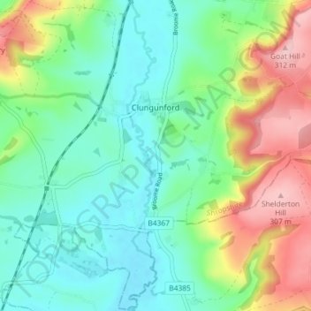
Name: Clungunford topographic map, elevation, terrain.
Location: Clungunford, Shropshire, England, United Kingdom (52.37408 -2.92604 52.41786 -2.85393)
Average elevation: 181 m
Minimum elevation: 120 m
Maximum elevation: 309 m
Thank you for supporting this site ❤️
Make a donation
Make a donation
Other topographic maps
Click on a map to view its topography, its elevation and its terrain.