
Thank you for supporting this site ❤️
Make a donation
Make a donation
Long Singut topographic map
Click on the map to display elevation.
Thank you for supporting this site ❤️
Make a donation
Make a donation
About this map
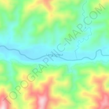
Name: Long Singut topographic map, elevation, terrain.
Location: Long Singut, Bukit Mabong, Kapit Division, Sarawak, Malaysia (1.55170 114.40021 1.59170 114.44021)
Average elevation: 413 m
Minimum elevation: 241 m
Maximum elevation: 746 m
Thank you for supporting this site ❤️
Make a donation
Make a donation
Other topographic maps
Click on a map to view its topography, its elevation and its terrain.