
Thank you for supporting this site ❤️
Make a donation
Make a donation
Ljusdal topographic map
Click on the map to display elevation.
Thank you for supporting this site ❤️
Make a donation
Make a donation
About this map
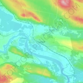
Name: Ljusdal topographic map, elevation, terrain.
Location: Ljusdal, Ljusdals kommun, Provinz Gävleborg, 827 00, Schweden (61.78938 16.05536 61.86938 16.13536)
Average elevation: 160 m
Minimum elevation: 116 m
Maximum elevation: 302 m
Thank you for supporting this site ❤️
Make a donation
Make a donation
Other topographic maps
Click on a map to view its topography, its elevation and its terrain.