
Make a donation
Monte de El Pardo topographic map
Click on the map to display elevation.
Make a donation
About this map
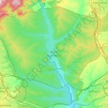
Name: Monte de El Pardo topographic map, elevation, terrain.
Location: Monte de El Pardo, Community of Madrid, Spain (40.46920 -3.88895 40.60987 -3.70546)
Average elevation: 689 m
Minimum elevation: 592 m
Maximum elevation: 907 m
Make a donation
Other topographic maps
Click on a map to view its topography, its elevation and its terrain.
Fuenlabrada
The highest point in the municipality (721 metres above sea level) is located in a hill to the northwest of the city proper. The city proper's altitude gently decreases from the Northwest to the Southeast; the lowest areas in the municipality (slightly over 600 metres above sea level) are located in the East,…
Average elevation: 665 m
Make a donation
Alcorcón
The municipality, largely flat, lies at an average altitude of 711 metres above sea level, with the highest point being El Ventorro del Cano (741 m), located in the north of the municipality.
Average elevation: 692 m
Make a donation
La Cabrera
La Cabrera is characterised by its mountainous topography with the prominent La Cabrera mountain range forming a natural limit to the North. The town is situated in the easternmost part of the range at about 1,038 m (3,406 ft) above sea level. Although most of the mountain range is in La Cabrera, it also…
Average elevation: 1,057 m
Make a donation
Navacerrada
Navacerrada is a municipality of the Community of Madrid, Spain. It lies at an elevation of 1,203 metres (3,947 ft) on the Reservoir Navacerrada and the entry of "Valle de la Barranca" in the Sierra de Guadarrama.
Average elevation: 1,460 m