
Thank you for supporting this site ❤️
Make a donation
Make a donation
Megalochori topographic map
Click on the map to display elevation.
Thank you for supporting this site ❤️
Make a donation
Make a donation
About this map
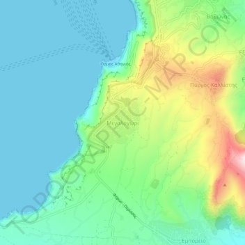
Name: Megalochori topographic map, elevation, terrain.
Average elevation: 124 m
Minimum elevation: -1 m
Maximum elevation: 456 m
Thank you for supporting this site ❤️
Make a donation
Make a donation
Other topographic maps
Click on a map to view its topography, its elevation and its terrain.
Nea Kameni
Greece > Aegean > Thira Regional Unit > Thira Municipal Unit > Fira
Average elevation: 16 m
Thank you for supporting this site ❤️
Make a donation
Make a donation