
Thank you for supporting this site ❤️
Make a donation
Make a donation
Gibson County topographic map
Click on the map to display elevation.
Thank you for supporting this site ❤️
Make a donation
Make a donation
About this map
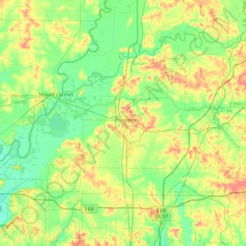
Name: Gibson County topographic map, elevation, terrain.
Location: Gibson County, Indiana, United States (38.16539 -87.98832 38.53273 -87.31570)
Average elevation: 136 m
Minimum elevation: 110 m
Maximum elevation: 195 m
Thank you for supporting this site ❤️
Make a donation
Make a donation
Other topographic maps
Click on a map to view its topography, its elevation and its terrain.