
Thank you for supporting this site ❤️
Make a donation
Make a donation
Bankim topographic map
Click on the map to display elevation.
Thank you for supporting this site ❤️
Make a donation
Make a donation
About this map
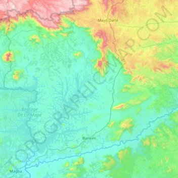
Name: Bankim topographic map, elevation, terrain.
Location: Bankim, Mayo-Banyo, Région de l'Adamaoua, Cameroun (5.97477 11.18261 6.53934 11.81780)
Average elevation: 891 m
Minimum elevation: 683 m
Maximum elevation: 1,819 m
Thank you for supporting this site ❤️
Make a donation
Make a donation
Other topographic maps
Click on a map to view its topography, its elevation and its terrain.