
Thank you for supporting this site ❤️
Make a donation
Make a donation
Bande Village topographic map
Click on the map to display elevation.
Thank you for supporting this site ❤️
Make a donation
Make a donation
About this map
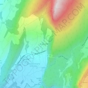
Name: Bande Village topographic map, elevation, terrain.
Average elevation: 676 m
Minimum elevation: 391 m
Maximum elevation: 1,300 m
Thank you for supporting this site ❤️
Make a donation
Make a donation
Other topographic maps
Click on a map to view its topography, its elevation and its terrain.
Le Guiers Vif
France > Auvergne-Rhône-Alpes > Savoie > Saint-Christophe > Saint-Christophe La Grotte
Average elevation: 414 m