
Make a donation
Kenabeek topographic map
Click on the map to display elevation.
Make a donation
About this map
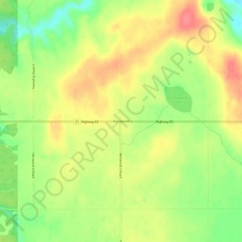
Name: Kenabeek topographic map, elevation, terrain.
Average elevation: 284 m
Minimum elevation: 249 m
Maximum elevation: 314 m
Make a donation
Other topographic maps
Click on a map to view its topography, its elevation and its terrain.
Lake Temiskaming
Canada > Ontario > Timiskaming District > Unorganized West Timiskaming
Average elevation: 279 m
Lady Evelyn Lake
Canada > Ontario > Timiskaming District > Unorganized West Timiskaming
Average elevation: 318 m
Henwood Lake
Canada > Ontario > Timiskaming District > Unorganized West Timiskaming
Average elevation: 288 m
Wabun Lake
Canada > Ontario > Timiskaming District > Unorganized West Timiskaming
Average elevation: 468 m
Make a donation
Boston Creek
Canada > Ontario > Timiskaming District > Unorganized West Timiskaming
Average elevation: 300 m
Wendigo Lake
Canada > Ontario > Timiskaming District > Unorganized West Timiskaming
Average elevation: 280 m
Flanagan Lake
Canada > Ontario > Timiskaming District > Unorganized West Timiskaming
Average elevation: 403 m
Wolf Creek
Canada > Ontario > Timiskaming District > Unorganized West Timiskaming
Average elevation: 327 m
Make a donation
Okiniada Lake
Canada > Ontario > Timiskaming District > Unorganized West Timiskaming
Average elevation: 468 m
Heart Lake
Canada > Ontario > Timiskaming District > Unorganized West Timiskaming > King Kirkland
Average elevation: 336 m
Kenogami Lake
Canada > Ontario > Timiskaming District > Unorganized West Timiskaming
Average elevation: 316 m
Hobart Lake
Canada > Ontario > Timiskaming District > Unorganized West Timiskaming
Average elevation: 305 m
Make a donation
Baptiste Creek;Baptiste Lake
Canada > Ontario > Timiskaming District > Unorganized West Timiskaming
Average elevation: 334 m
Lady Evelyn Lake
Canada > Ontario > Timiskaming District > Unorganized West Timiskaming
Average elevation: 318 m