
Make a donation
Strausberg topographic map
Click on the map to display elevation.
Make a donation
Strausberg
Zur Stadt gehört der Ortsteil Hohenstein mit den Wohnplätzen Gladowshöhe und Ruhlsdorf. Darüber hinaus existieren die folgenden 16 Wohnplätze: Alte Walkmühle, Fasanenpark, Friedrich-Schiller-Höhe, Gartenstadt, Hohensteiner Mühle, Jenseits des Sees, Neue Mühle, Postbruch, Provinzialsiedlung, Roter Hof, Spitzmühle, Steuerhaus, Torfhaus, Treuenhof und Wilhelmshof.
Make a donation
About this map
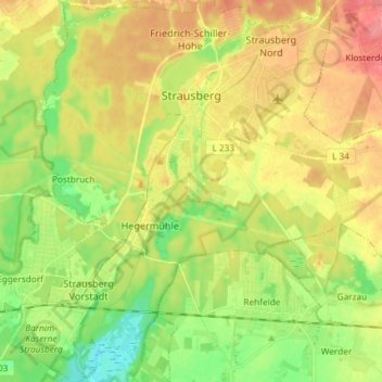
Name: Strausberg topographic map, elevation, terrain.
Location: Strausberg, Märkisch-Oderland, Brandenburg, Deutschland (52.51420 13.81318 52.60352 13.94035)
Average elevation: 69 m
Minimum elevation: 35 m
Maximum elevation: 106 m
Make a donation
Other topographic maps
Click on a map to view its topography, its elevation and its terrain.
Straussee
Deutschland > Brandenburg > Märkisch-Oderland > Strausberg > Strausberg
Average elevation: 75 m
Neue Mühle
Deutschland > Brandenburg > Märkisch-Oderland > Strausberg > Strausberg
Average elevation: 55 m