Salt Lick topographic map
Interactive map
Click on the map to display elevation.
About this map
![Salt Lick topographic map, elevation, terrain](/pub/maps/relation/857/t88rr/thumbnail.jpg)
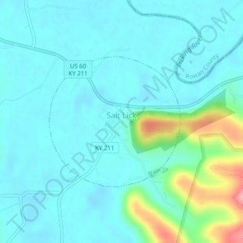
Name: Salt Lick topographic map, elevation, terrain.
Location: Salt Lick, Bath County, Kentucky, United States (38.11210 -83.62489 38.12657 -83.60631)
Average elevation: 217 m
Minimum elevation: 195 m
Maximum elevation: 316 m
Other topographic maps
Click on a map to view its topography, its elevation and its terrain.
![Sharpsburg topographic map, elevation, terrain](/pub/maps/relation/bm2/v44cz/icon.jpg)
Sharpsburg
United States > Kentucky > Bath County
Sharpsburg, Bath County, Kentucky, United States
Average elevation: 297 m
![Olympia topographic map, elevation, terrain](/pub/maps/node/lzb3/jvsfj5k/icon.jpg)
Olympia
United States > Kentucky > Bath County
Olympia, Bath County, Kentucky, 40358, United States
Average elevation: 248 m
![Owingsville topographic map, elevation, terrain](/pub/maps/relation/35k/36dtp/icon.jpg)
Owingsville
United States > Kentucky > Bath County
Owingsville, Bath County, Kentucky, 40360, United States
Average elevation: 262 m
![Pioneer Weapons Wildlife Management Area topographic map, elevation, terrain](/pub/maps/node/fnh/62nlss51/icon.jpg)
Pioneer Weapons Wildlife Management Area
United States > Kentucky > Bath County
Pioneer Weapons Wildlife Management Area, Bath County, Kentucky, United States
Average elevation: 323 m