
Thank you for supporting this site ❤️
Make a donation
Make a donation
66459 topographic map
Click on the map to display elevation.
Thank you for supporting this site ❤️
Make a donation
Make a donation
About this map
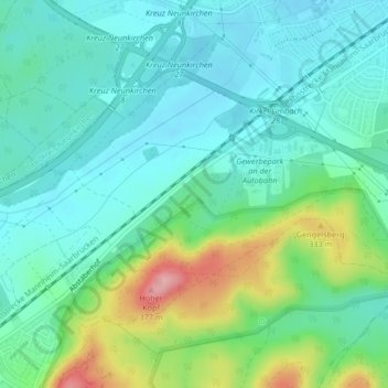
Name: 66459 topographic map, elevation, terrain.
Location: 66459, Limbach, Kirkel, Saarpfalz-Kreis, Saarland, Deutschland (49.30009 7.25887 49.30019 7.25897)
Average elevation: 267 m
Minimum elevation: 228 m
Maximum elevation: 379 m
Thank you for supporting this site ❤️
Make a donation
Make a donation
Other topographic maps
Click on a map to view its topography, its elevation and its terrain.