
Thank you for supporting this site ❤️
Make a donation
Make a donation
Bölkum topographic map
Click on the map to display elevation.
Thank you for supporting this site ❤️
Make a donation
Make a donation
Bölkum
Der Weiler liegt in einer Höhe von 240 m ü. NHN auf den Hängen des Bergischen Landes. Nachbarorte sind Stranzenbach im Nordosten, Hodgeroth im Südosten und Röttgen im Nordosten.
Thank you for supporting this site ❤️
Make a donation
Make a donation
About this map
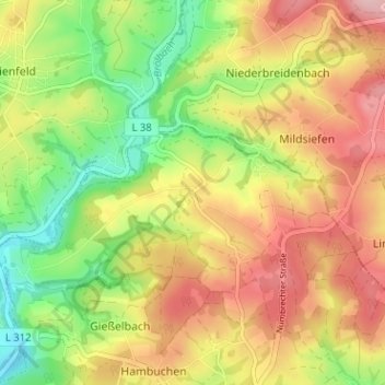
Name: Bölkum topographic map, elevation, terrain.
Average elevation: 226 m
Minimum elevation: 142 m
Maximum elevation: 307 m
Thank you for supporting this site ❤️
Make a donation
Make a donation