
Thank you for supporting this site ❤️
Make a donation
Make a donation
Fürstenberg topographic map
Click on the map to display elevation.
Thank you for supporting this site ❤️
Make a donation
Make a donation
Fürstenberg
Fürstenberg ist ein Stadtteil von Hüfingen, westlich gelegen unterhalb des Berges Fürstenberg. Fürstenberg war ursprünglich eine eigene Stadt, die ihren Ursprung oben auf dem Fürstenberg auf 917 m Meereshöhe bei der Burg Fürstenberg hatte. Dies war eine Burgstadt und erster Stammsitz der Fürstenberger.
Thank you for supporting this site ❤️
Make a donation
Make a donation
About this map
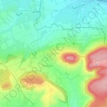
Name: Fürstenberg topographic map, elevation, terrain.
Average elevation: 762 m
Minimum elevation: 666 m
Maximum elevation: 940 m
Thank you for supporting this site ❤️
Make a donation
Make a donation
Other topographic maps
Click on a map to view its topography, its elevation and its terrain.
Sumpfohren
Deutschland > Baden-Württemberg > Schwarzwald-Baar-Kreis > Hüfingen
Average elevation: 700 m