
Thank you for supporting this site ❤️
Make a donation
Make a donation
Srisailam topographic map
Click on the map to display elevation.
Thank you for supporting this site ❤️
Make a donation
Make a donation
About this map
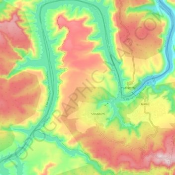
Name: Srisailam topographic map, elevation, terrain.
Location: Srisailam, Nandyal District, Andhra Pradesh, India (16.03342 78.82901 16.14922 78.93093)
Average elevation: 435 m
Minimum elevation: 159 m
Maximum elevation: 745 m
Thank you for supporting this site ❤️
Make a donation
Make a donation
Other topographic maps
Click on a map to view its topography, its elevation and its terrain.