
Make a donation
Arkansas topographic map
Click on the map to display elevation.
Make a donation
About this map
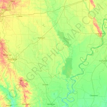
Name: Arkansas topographic map, elevation, terrain.
Location: Arkansas, Arkansas County, Arkansas, United States (33.59025 -92.05985 34.99025 -90.65985)
Average elevation: 58 m
Minimum elevation: 30 m
Maximum elevation: 149 m
Make a donation
Other topographic maps
Click on a map to view its topography, its elevation and its terrain.
Crater of Diamonds State Park
United States > Arkansas > Pike County > Murfreesboro > Kimberley
Average elevation: 106 m
Make a donation
Make a donation
Mississippi County
Local oral tradition held that prior to the major earthquakes of 1812, the lands in Mississippi County were higher in elevation compared to now and were not prone to flooding. Though the earthquake was named for New Madrid, Missouri, as that was the only town in the area with any population, the actual…
Average elevation: 75 m
Make a donation
Make a donation
Make a donation
Make a donation
Beaver Lake
United States > Arkansas > Benton County > Goshen
Beaver Dam was authorized by the Flood Control Act of 1944 and other following acts. The United States Army Corps of Engineers constructed Beaver Dam during the years 1960-1966, impounding a major part of the White River and creating Beaver Lake and flooding much of the valley including the remains of the…
Average elevation: 392 m
Make a donation
Make a donation
Make a donation
Make a donation
Make a donation
Make a donation
Make a donation
Make a donation
Make a donation
Make a donation
Make a donation
Make a donation
Make a donation
Make a donation
Make a donation
Make a donation
Make a donation
Make a donation
Make a donation