
Thank you for supporting this site ❤️
Make a donation
Make a donation
Nalkan topographic map
Click on the map to display elevation.
Thank you for supporting this site ❤️
Make a donation
Make a donation
About this map
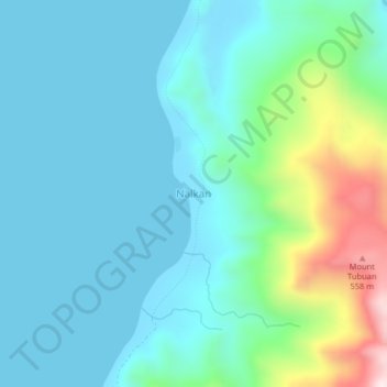
Name: Nalkan topographic map, elevation, terrain.
Location: Nalkan, Maguindanao del Norte, Bangsamoro, 9623, Philippines (6.98804 123.97635 7.02804 124.01635)
Average elevation: 121 m
Minimum elevation: 0 m
Maximum elevation: 627 m
Thank you for supporting this site ❤️
Make a donation
Make a donation
Other topographic maps
Click on a map to view its topography, its elevation and its terrain.