
Thank you for supporting this site ❤️
Make a donation
Make a donation
Fougeras topographic map
Click on the map to display elevation.
Thank you for supporting this site ❤️
Make a donation
Make a donation
About this map
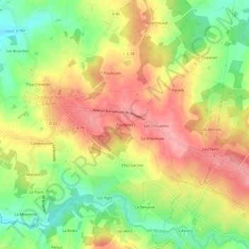
Name: Fougeras topographic map, elevation, terrain.
Average elevation: 319 m
Minimum elevation: 263 m
Maximum elevation: 368 m
Thank you for supporting this site ❤️
Make a donation
Make a donation
Other topographic maps
Click on a map to view its topography, its elevation and its terrain.
87150
France > Nouvelle-Aquitaine > Haute-Vienne > Oradour-sur-Vayres > Les Ages
Average elevation: 331 m