
Thank you for supporting this site ❤️
Make a donation
Make a donation
Puig Major topographic map
Click on the map to display elevation.
Thank you for supporting this site ❤️
Make a donation
Make a donation
Puig Major
Puig Major is the highest peak on the Spanish island of Majorca. With an elevation of 1,436 m (4,711 ft) above sea level. It is situated in the Serra de Tramuntana mountains. As the mountain is located in a military zone, the neighbouring peak Puig de Massanella (1,364 m) is considered the highest accessible summit on the island.
Thank you for supporting this site ❤️
Make a donation
Make a donation
About this map
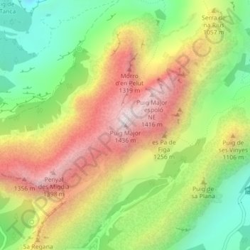
Name: Puig Major topographic map, elevation, terrain.
Average elevation: 949 m
Minimum elevation: 510 m
Maximum elevation: 1,444 m
Thank you for supporting this site ❤️
Make a donation
Make a donation