
Thank you for supporting this site ❤️
Make a donation
Make a donation
Lambert les Hauts topographic map
Click on the map to display elevation.
Thank you for supporting this site ❤️
Make a donation
Make a donation
About this map
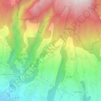
Name: Lambert les Hauts topographic map, elevation, terrain.
Average elevation: 505 m
Minimum elevation: 58 m
Maximum elevation: 1,054 m
Thank you for supporting this site ❤️
Make a donation
Make a donation
Other topographic maps
Click on a map to view its topography, its elevation and its terrain.
Forêt Départemento-Domaniale de l'Étang-Salé
France > La Réunion > L'Étang-Salé > L'Étang-Salé les Bains
Average elevation: 63 m
Thank you for supporting this site ❤️
Make a donation
Make a donation