Clear Lake topographic map
Interactive map
Click on the map to display elevation.
About this map
![Clear Lake topographic map, elevation, terrain](/pub/maps/relation/hrtp/k78z4/thumbnail.jpg)
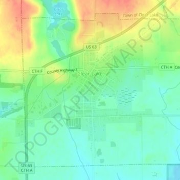
Name: Clear Lake topographic map, elevation, terrain.
Location: Clear Lake, Polk County, Wisconsin, United States (45.23786 -92.28591 45.26094 -92.24961)
Average elevation: 362 m
Minimum elevation: 342 m
Maximum elevation: 393 m
Other topographic maps
Click on a map to view its topography, its elevation and its terrain.
![Osceola topographic map, elevation, terrain](/pub/maps/relation/m114/hpc3q/icon.jpg)
Osceola
United States > Wisconsin > Polk County
Osceola, Polk County, Wisconsin, United States
Average elevation: 261 m
![Luck topographic map, elevation, terrain](/pub/maps/relation/lp4s/6d4gp/icon.jpg)
Luck
United States > Wisconsin > Polk County
Luck, Polk County, Wisconsin, United States
Average elevation: 379 m
![Wild River State Park topographic map, elevation, terrain](/pub/maps/way/7c18/qbhj8tj/icon.jpg)
Wild River State Park
United States > Wisconsin > Polk County
Wild River State Park, Town of Sterling, Polk County, Wisconsin, 54006, United States
Average elevation: 262 m
![Balsam Lake topographic map, elevation, terrain](/pub/maps/relation/3ts8/s3n51/icon.jpg)
Balsam Lake
United States > Wisconsin > Polk County
Balsam Lake, Polk County, Wisconsin, United States
Average elevation: 354 m
![Town of Bone Lake topographic map, elevation, terrain](/pub/maps/relation/gznx/xhd51h/icon.jpg)
Town of Bone Lake
United States > Wisconsin > Polk County
Town of Bone Lake, Polk County, Wisconsin, United States
Average elevation: 378 m
![Clayton topographic map, elevation, terrain](/pub/maps/relation/25rr/5b6tf/icon.jpg)
Clayton
United States > Wisconsin > Polk County
Clayton, Polk County, Wisconsin, United States
Average elevation: 370 m
![Frederic topographic map, elevation, terrain](/pub/maps/relation/42nh/dfhgt/icon.jpg)
Frederic
United States > Wisconsin > Polk County
Frederic, Polk County, Wisconsin, United States
Average elevation: 373 m
![Little Falls topographic map, elevation, terrain](/pub/maps/node/9fzs/5cjd757/icon.jpg)
Little Falls
United States > Wisconsin > Polk County
Little Falls, Town of Alden, Polk County, Wisconsin, United States
Average elevation: 326 m
![Peaslee Lake topographic map, elevation, terrain](/pub/maps/way/rrnx/d8trtkl/icon.jpg)
Peaslee Lake
United States > Wisconsin > Polk County
Peaslee Lake, Town of Osceola, Polk County, Wisconsin, United States
Average elevation: 241 m
![Clear Lake Village Park topographic map, elevation, terrain](/pub/maps/relation/lpb3/jzvss8/icon.jpg)
Clear Lake Village Park
United States > Wisconsin > Polk County > Clear Lake
Clear Lake Village Park, Clear Lake, Town of Clear Lake, Polk County, Wisconsin, United States
Average elevation: 368 m
![Cushing topographic map, elevation, terrain](/pub/maps/node/q2nx/z1d7xnx/icon.jpg)
Cushing
United States > Wisconsin > Polk County
Cushing, Town of Laketown, Polk County, Wisconsin, 54006, United States
Average elevation: 298 m
![Amery topographic map, elevation, terrain](/pub/maps/relation/spf3/k7814/icon.jpg)
Amery
United States > Wisconsin > Polk County
Amery, Polk County, Wisconsin, United States
Average elevation: 330 m