
Make a donation
Globe topographic map
Click on the map to display elevation.
Make a donation
Globe
Globe has a semi-arid climate, characterized by hot summers and moderate to warm winters. Globe's arid climate is somewhat tempered by its elevation, however, leading to slightly cooler temperatures and slightly more precipitation than Phoenix or Yuma.
Make a donation
About this map
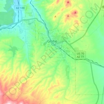
Name: Globe topographic map, elevation, terrain.
Location: Globe, Gila County, Arizona, 85532, United States (33.33891 -110.84063 33.42931 -110.70812)
Average elevation: 1,173 m
Minimum elevation: 985 m
Maximum elevation: 1,589 m
Make a donation
Other topographic maps
Click on a map to view its topography, its elevation and its terrain.
Make a donation
Make a donation
Star Valley
United States > Arizona > Gila County > Star Valley
According to the United States Census Bureau, the town has a total area of 36.1 square miles (93.6 km2), of which 0.01 square miles (0.02 km2), or 0.03%, is water. Star Valley sits at an elevation of 4,650 feet (1,420 m) and takes its name from the valley in which it is located, formed by Houston Creek, which…
Average elevation: 1,521 m
Make a donation