
Croix Fer topographic map
Interactive map
Click on the map to display elevation.
About this map
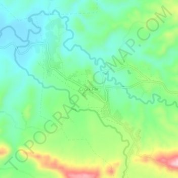
Name: Croix Fer topographic map, elevation, terrain.
Average elevation: 280 m
Minimum elevation: 200 m
Maximum elevation: 457 m
Other topographic maps
Click on a map to view its topography, its elevation and its terrain.
Belladère
Haïti > Département du Centre > Commune de Belladère
Belladère, Commune de Belladère, Arrondissement Lascahobas, Département du Centre, Haïti
Average elevation: 413 m