
Thank you for supporting this site ❤️
Make a donation
Make a donation
Albulapass topographic map
Click on the map to display elevation.
Thank you for supporting this site ❤️
Make a donation
Make a donation
Albulapass
The Albula Pass is an important axis from central Graubünden to Engadin. It is traversed by a paved road from Thusis to La Punt, via Bergün. It is also traversed by the Albula Railway, although at a lower elevation through the Albula Tunnel (1,820 m), from Thusis to Bever, also via Bergün.
Thank you for supporting this site ❤️
Make a donation
Make a donation
About this map
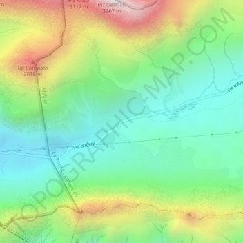
Name: Albulapass topographic map, elevation, terrain.
Average elevation: 2,560 m
Minimum elevation: 2,202 m
Maximum elevation: 3,228 m
Thank you for supporting this site ❤️
Make a donation
Make a donation