
Océan Atlantique topographic map
Interactive map
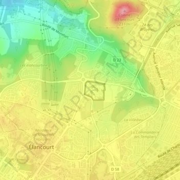
Click on the map to display elevation.
About this map
Name: Océan Atlantique topographic map, elevation, terrain.
Average elevation: 163 m
Minimum elevation: 100 m
Maximum elevation: 219 m
Other topographic maps
Click on a map to view its topography, its elevation and its terrain.
Colline d'Élancourt
France > Île-de-France > Yvelines > Élancourt
Colline d'Élancourt, La Pat au Long Cours, La Clef de Saint-Pierre, Élancourt, Rambouillet, Yvelines, Île-de-France, France métropolitaine, 78990, France
Average elevation: 163 m