
Thank you for supporting this site ❤️
Make a donation
Make a donation
Mwera topographic map
Click on the map to display elevation.
Thank you for supporting this site ❤️
Make a donation
Make a donation
About this map
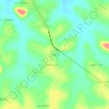
Name: Mwera topographic map, elevation, terrain.
Location: Mwera, Wakiso, Central Region, Uganda (0.43371 32.31467 0.47371 32.35467)
Average elevation: 1,143 m
Minimum elevation: 1,110 m
Maximum elevation: 1,211 m
Thank you for supporting this site ❤️
Make a donation
Make a donation
Other topographic maps
Click on a map to view its topography, its elevation and its terrain.