
Thank you for supporting this site ❤️
Make a donation
Make a donation
Langeland topographic map
Click on the map to display elevation.
Thank you for supporting this site ❤️
Make a donation
Make a donation
About this map
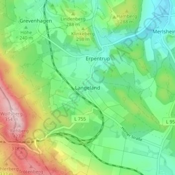
Name: Langeland topographic map, elevation, terrain.
Average elevation: 269 m
Minimum elevation: 188 m
Maximum elevation: 430 m
Thank you for supporting this site ❤️
Make a donation
Make a donation
Other topographic maps
Click on a map to view its topography, its elevation and its terrain.
Reelsen
Deutschland > Nordrhein-Westfalen > Kreis Höxter > Bad Driburg
Reelsen liegt auf ungefähr 220 m Höhe über NN ca. 3 km nördlich von Bad Driburg und wird weiterhin von den Ortschaften Alhausen, Bad Hermannsborn, Bembüren, Merlsheim und Langeland umgeben. Naturräumlich gehört Reelsen bereits zum Sandebecker Hügelland im östlichen Egge-Vorland des Niedersächsischen…
Average elevation: 278 m