
Thank you for supporting this site ❤️
Make a donation
Make a donation
Stolberg topographic map
Click on the map to display elevation.
Thank you for supporting this site ❤️
Make a donation
Make a donation
About this map
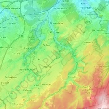
Name: Stolberg topographic map, elevation, terrain.
Location: Stolberg, Städteregion Aachen, North Rhine-Westphalia, Germany (50.68470 6.17453 50.80557 6.36561)
Average elevation: 266 m
Minimum elevation: 143 m
Maximum elevation: 502 m
Thank you for supporting this site ❤️
Make a donation
Make a donation
Other topographic maps
Click on a map to view its topography, its elevation and its terrain.
Schevenhütte
Germany > North Rhine-Westphalia > Städteregion Aachen > Stolberg
Average elevation: 244 m
Bend
Germany > North Rhine-Westphalia > Städteregion Aachen > Stolberg > Schevenhütte
Average elevation: 267 m
Thank you for supporting this site ❤️
Make a donation
Make a donation