
Make a donation
Holt topographic map
Click on the map to display elevation.
Make a donation
About this map
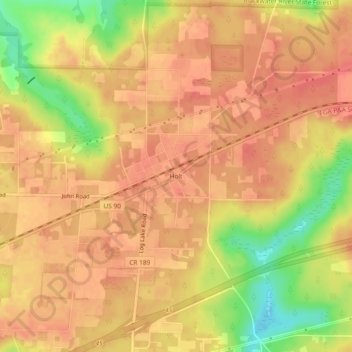
Name: Holt topographic map, elevation, terrain.
Location: Holt, Okaloosa County, Florida, 32546, United States (30.69575 -86.76579 30.73575 -86.72579)
Average elevation: 53 m
Minimum elevation: 15 m
Maximum elevation: 68 m
Make a donation
Other topographic maps
Click on a map to view its topography, its elevation and its terrain.
Crestview
United States > Florida > Okaloosa County
Crestview is a city in Okaloosa County, Florida, United States. The population was 27,134 at the 2020 census, up from 20,978 at the 2010 census. It is the county seat of Okaloosa County. With an elevation of 235 feet (72 m) above sea level, it is one of the highest points in the state; it receives 65 inches…
Average elevation: 43 m
Make a donation
Eglin Air Force Base
United States > Florida > Okaloosa County
Eglin is known to have been used for 441 launches from 1959 to 1980, reaching up to 686 kilometers altitude.[51]
Average elevation: 12 m
Make a donation
Crestview
United States > Florida > Okaloosa County
Crestview is the largest city and county seat of Okaloosa County, Florida, United States. The population was 27,134 at the 2020 census, up from 20,978 at the 2010 census. With an elevation of 236 feet (72 m) above sea level, it is one of the highest points in the state.
Average elevation: 43 m
Make a donation
Crestview
United States > Florida > Okaloosa County
Crestview is a city in Okaloosa County, Florida, United States. The population was 27,134 at the 2020 census, up from 20,978 at the 2010 census. It is the county seat of Okaloosa County. With an elevation of 235 feet (72 m) above sea level, it is one of the highest points in the state; it receives 65 inches…
Average elevation: 43 m