
Thank you for supporting this site ❤️
Make a donation
Make a donation
Good Thunder topographic map
Click on the map to display elevation.
Thank you for supporting this site ❤️
Make a donation
Make a donation
About this map
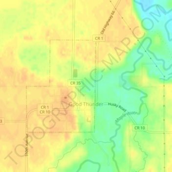
Name: Good Thunder topographic map, elevation, terrain.
Location: Good Thunder, Blue Earth County, Minnesota, United States (44.00024 -94.07886 44.01477 -94.06351)
Average elevation: 301 m
Minimum elevation: 280 m
Maximum elevation: 311 m
Thank you for supporting this site ❤️
Make a donation
Make a donation
Other topographic maps
Click on a map to view its topography, its elevation and its terrain.
Thank you for supporting this site ❤️
Make a donation
Make a donation
Lime Valley Mobile Home Park
United States > Minnesota > Blue Earth County > Mankato
Average elevation: 275 m