
Thank you for supporting this site ❤️
Make a donation
Make a donation
Glencoe topographic map
Click on the map to display elevation.
Thank you for supporting this site ❤️
Make a donation
Make a donation
About this map
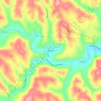
Name: Glencoe topographic map, elevation, terrain.
Location: Glencoe, Belmont County, Ohio, 43928, United States (39.98813 -80.90759 40.02813 -80.86759)
Average elevation: 317 m
Minimum elevation: 238 m
Maximum elevation: 388 m
Thank you for supporting this site ❤️
Make a donation
Make a donation
Other topographic maps
Click on a map to view its topography, its elevation and its terrain.
Thank you for supporting this site ❤️
Make a donation
Make a donation
Thank you for supporting this site ❤️
Make a donation
Make a donation
Thank you for supporting this site ❤️
Make a donation
Make a donation