
Thank you for supporting this site ❤️
Make a donation
Make a donation
Homfeld topographic map
Click on the map to display elevation.
Thank you for supporting this site ❤️
Make a donation
Make a donation
About this map
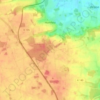
Name: Homfeld topographic map, elevation, terrain.
Average elevation: 47 m
Minimum elevation: 17 m
Maximum elevation: 66 m
Thank you for supporting this site ❤️
Make a donation
Make a donation
Other topographic maps
Click on a map to view its topography, its elevation and its terrain.
Otersen
Deutschland > Niedersachsen > Landkreis Diepholz > Bruchhausen-Vilsen > Süstedt
Average elevation: 50 m
Scholen
Deutschland > Niedersachsen > Landkreis Diepholz > Bruchhausen-Vilsen > Scholen
Average elevation: 56 m