
Thank you for supporting this site ❤️
Make a donation
Make a donation
Leiva topographic map
Click on the map to display elevation.
Thank you for supporting this site ❤️
Make a donation
Make a donation
About this map
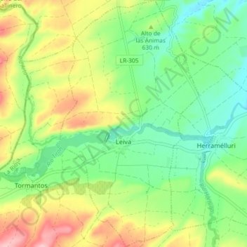
Name: Leiva topographic map, elevation, terrain.
Location: Leiva, Rioja, Spain (42.48035 -3.06618 42.53333 -3.02448)
Average elevation: 617 m
Minimum elevation: 548 m
Maximum elevation: 727 m
Thank you for supporting this site ❤️
Make a donation
Make a donation
Other topographic maps
Click on a map to view its topography, its elevation and its terrain.
Thank you for supporting this site ❤️
Make a donation
Make a donation
Thank you for supporting this site ❤️
Make a donation
Make a donation