
Thank you for supporting this site ❤️
Make a donation
Make a donation
Wönkhausen topographic map
Click on the map to display elevation.
Thank you for supporting this site ❤️
Make a donation
Make a donation
About this map
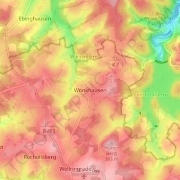
Name: Wönkhausen topographic map, elevation, terrain.
Average elevation: 350 m
Minimum elevation: 261 m
Maximum elevation: 397 m
Thank you for supporting this site ❤️
Make a donation
Make a donation
Other topographic maps
Click on a map to view its topography, its elevation and its terrain.
Wuppertalsperre
Deutschland > Nordrhein-Westfalen > Oberbergischer Kreis > Radevormwald > Honsberg
Average elevation: 295 m
42477
Deutschland > Nordrhein-Westfalen > Oberbergischer Kreis > Radevormwald > Rochollsberg
Average elevation: 359 m