
Thank you for supporting this site ❤️
Make a donation
Make a donation
Mont Vert les Hauts topographic map
Click on the map to display elevation.
Thank you for supporting this site ❤️
Make a donation
Make a donation
About this map
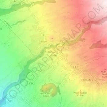
Name: Mont Vert les Hauts topographic map, elevation, terrain.
Location: Mont Vert les Hauts, Saint-Pierre, La Réunion, 97429, France (-21.33472 55.52168 -21.29472 55.56168)
Average elevation: 589 m
Minimum elevation: 232 m
Maximum elevation: 925 m
Thank you for supporting this site ❤️
Make a donation
Make a donation
Other topographic maps
Click on a map to view its topography, its elevation and its terrain.