
Thank you for supporting this site ❤️
Make a donation
Make a donation
Barrax topographic map
Click on the map to display elevation.
Thank you for supporting this site ❤️
Make a donation
Make a donation
Barrax
El relieve del municipio es predominantemente llano, con algunos cerros aislados, estando atravesado por el canal del Trasvase Tajo-Segura y por el río Lezuza. La altitud oscila entre los 859 metros al suroeste (cerro El Guijarral) y los 700 metros a orillas del río Lezuza. El pueblo se alza a 740 metros sobre el nivel del mar.
Thank you for supporting this site ❤️
Make a donation
Make a donation
About this map
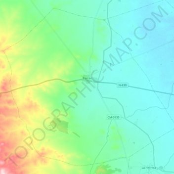
Name: Barrax topographic map, elevation, terrain.
Location: Barrax, Castilla-La Mancha, España (38.96454 -2.30040 39.11089 -2.09278)
Average elevation: 749 m
Minimum elevation: 694 m
Maximum elevation: 938 m
Thank you for supporting this site ❤️
Make a donation
Make a donation
Other topographic maps
Click on a map to view its topography, its elevation and its terrain.
Thank you for supporting this site ❤️
Make a donation
Make a donation
Thank you for supporting this site ❤️
Make a donation
Make a donation
Thank you for supporting this site ❤️
Make a donation
Make a donation
Cerro del Aljibe
España > Castilla-La Mancha > Campo de Calatrava > Carrión de Calatrava
Average elevation: 624 m
Thank you for supporting this site ❤️
Make a donation
Make a donation