
Wellin topographic map
Interactive map
Click on the map to display elevation.
About this map
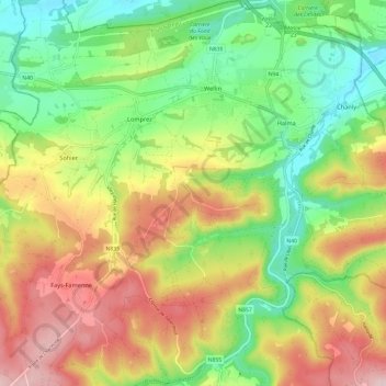
Name: Wellin topographic map, elevation, terrain.
Location: Wellin, Neufchâteau, Luxembourg, Wallonie, 6920, Belgique (50.02332 5.08634 50.09972 5.13658)
Average elevation: 293 m
Minimum elevation: 179 m
Maximum elevation: 439 m
Other topographic maps
Click on a map to view its topography, its elevation and its terrain.
Chanly
Belgique > Luxembourg > Neufchâteau > Wellin
Chanly, Wellin, Neufchâteau, Luxembourg, Wallonie, 6921, Belgique
Average elevation: 277 m
Wellin
Belgique > Luxembourg > Neufchâteau > Wellin
Wellin, Neufchâteau, Luxembourg, Wallonie, 6920, Belgique
Average elevation: 255 m
Lomprez
Belgique > Luxembourg > Neufchâteau > Wellin
Lomprez, Wellin, Neufchâteau, Luxembourg, Wallonie, 6924, Belgique
Average elevation: 306 m