
Make a donation
Montague Township topographic map
Click on the map to display elevation.
Make a donation
Montague Township
Montague Township is a township in Sussex County, in the U.S. state of New Jersey, in the New York City Metropolitan Area. As of the 2020 United States census, the township's population was 3,792, a decrease of 55 (−1.4%) from the 2010 census count of 3,847, which in turn reflected an increase of 435 (+12.7%) from the 3,412 counted in the 2000 census. High Point, within Montague Township, is the highest elevation within New Jersey at an altitude of 1,803 feet (550 m) above sea level. Montague is also the northernmost municipality in the state of New Jersey.
Make a donation
About this map
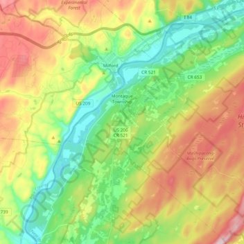
Name: Montague Township topographic map, elevation, terrain.
Average elevation: 254 m
Minimum elevation: 103 m
Maximum elevation: 482 m
Make a donation
Other topographic maps
Click on a map to view its topography, its elevation and its terrain.
High Point
United States > New Jersey > Sussex County > Montague Township
High Point is a mountain peak within High Point State Park on the border of Wantage Township and Montague Township, Sussex County, New Jersey. Located in the portion of the state known as the Skylands, it is the highest elevation in the state, with a peak elevation of 1,803 feet (550 m). The closest city is…
Average elevation: 415 m
Make a donation
Kittatinny Mountain
United States > New Jersey > Sussex County
Kittatinny Mountain (Lenape: Kitahtëne) is a long ridge traversing primarily across Sussex County in northwestern New Jersey, running in a northeast-southwest axis, a continuation across the Delaware Water Gap of Pennsylvania's Blue Mountain (also known as Kittatinny Ridge). It is the first major ridge in the…
Average elevation: 266 m
Make a donation
Make a donation
Make a donation
High Point
United States > New Jersey > Sussex County > Montague Township
High Point is a mountain peak within High Point State Park on the border of Wantage Township and Montague Township, Sussex County, New Jersey, United States. Located in the portion of the state known as the Skylands, it is the highest elevation in the state, with a peak elevation of 1,803 feet (550 m). The…
Average elevation: 415 m
Halsey
United States > New Jersey > Sussex County > Hampton Township > Hampton Township
Average elevation: 186 m
Make a donation
Hampton Township
United States > New Jersey > Sussex County > Hampton Township
Average elevation: 202 m
Montague
United States > New Jersey > Sussex County > Montague Township > Montague
Average elevation: 178 m
Make a donation
Wallpack Center
United States > New Jersey > Sussex County > Wallpack Township
Average elevation: 179 m