
Thank you for supporting this site ❤️
Make a donation
Make a donation
Schwalenberg topographic map
Click on the map to display elevation.
Thank you for supporting this site ❤️
Make a donation
Make a donation
About this map
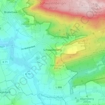
Name: Schwalenberg topographic map, elevation, terrain.
Average elevation: 239 m
Minimum elevation: 149 m
Maximum elevation: 452 m
Thank you for supporting this site ❤️
Make a donation
Make a donation
Other topographic maps
Click on a map to view its topography, its elevation and its terrain.
Vogelhorst
Deutschland > Nordrhein-Westfalen > Kreis Lippe > Lemgo > Voßheide
Average elevation: 143 m
Thank you for supporting this site ❤️
Make a donation
Make a donation