Geolocate

侯家营镇 topographic map

Interactive map

Click on the map to display elevation.

About this map

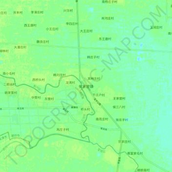
Name: 侯家营镇 topographic map, elevation, terrain.

Location: 侯家营镇, 蓟州区, 天津市, 中国 (39.81503 117.20845 39.89503 117.28845)

Average elevation: 9 m

Minimum elevation: 3 m

Maximum elevation: 13 m

Other topographic maps

Click on a map to view its topography, its elevation and its terrain.

前牛宫村

中国 > 天津市 > 蓟州区

前牛宫村, 蓟州区, 天津市, 中国

Average elevation: 11 m

许有庄村

中国 > 天津市 > 蓟州区

许有庄村, 蓟州区, 天津市, 中国

Average elevation: 9 m

水泉地

中国 > 天津市 > 蓟州区 > 狐狸峪村

水泉地, 狐狸峪村, 蓟州区, 天津市, 中国

Average elevation: 231 m

下仓镇

中国 > 天津市 > 蓟州区

下仓镇, 蓟州区, 天津市, 中国

Average elevation: 6 m

小龙卧村

中国 > 天津市 > 蓟州区

小龙卧村, 蓟州区, 天津市, 中国

Average elevation: 11 m

三里庄村

中国 > 天津市 > 蓟州区

三里庄村, 蓟州区, 天津市, 301900, 中国

Average elevation: 16 m

肖庄户村

中国 > 天津市 > 蓟州区

肖庄户村, 蓟州区, 天津市, 中国

Average elevation: 47 m

三家店村

中国 > 天津市 > 蓟州区

三家店村, 蓟州区, 天津市, 中国

Average elevation: 64 m

州河

中国 > 天津市 > 蓟州区

州河, 蓟州区, 天津市, 中国

Average elevation: 7 m

州河

中国 > 天津市 > 蓟州区

州河, 蓟州区, 蓟县, 天津市, 301900, 中国

Average elevation: 60 m