
Flevoland topographic map
Interactive map
Click on the map to display elevation.
About this map
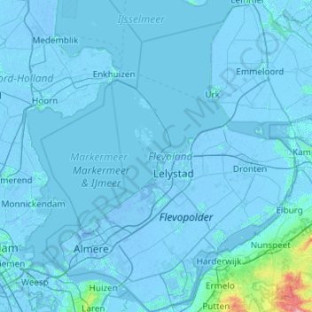
Name: Flevoland topographic map, elevation, terrain.
Location: Flevoland, Nederland (52.24953 5.06043 52.84398 6.01730)
Average elevation: 1 m
Minimum elevation: -9 m
Maximum elevation: 96 m
Other topographic maps
Click on a map to view its topography, its elevation and its terrain.
Heemskerk
Nederland > Noord-Holland > Heemskerk
Heemskerk, Noord-Holland, Nederland
Average elevation: 3 m
Blaricum
Nederland > Noord-Holland > Blaricum
Blaricum, Noord-Holland, Nederland
Average elevation: 0 m
Castricum
Nederland > Noord-Holland > Castricum
Castricum, Noord-Holland, Nederland
Average elevation: 3 m
Alphen aan den Rijn
Alphen aan den Rijn, Zuid-Holland, Nederland
Average elevation: -2 m
Harderwijk
Nederland > Gelderland > Harderwijk
Harderwijk, Gelderland, Nederland
Average elevation: 7 m
Valkenburg
Nederland > Limburg > Valkenburg
Valkenburg, Limburg, Nederland, 6301, Nederland
Average elevation: 121 m
Gorinchem
Nederland > Zuid-Holland > Gorinchem
Gorinchem, Zuid-Holland, Nederland
Average elevation: 1 m
Driebergen-Rijsenburg
Driebergen-Rijsenburg, Utrechtse Heuvelrug, Utrecht, Nederland
Average elevation: 8 m
Naarden
Naarden, Gooise Meren, Noord-Holland, Nederland
Average elevation: 2 m