
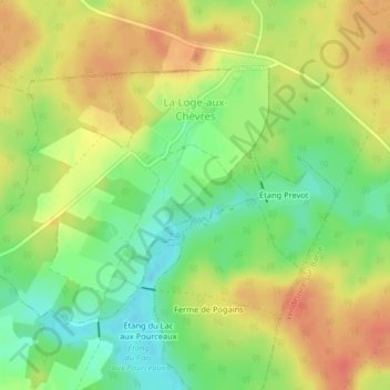
La Loge-aux-Chèvres topographic map
Interactive map
Click on the map to display elevation.
About this map
Name: La Loge-aux-Chèvres topographic map, elevation, terrain.
Average elevation: 168 m
Minimum elevation: 142 m
Maximum elevation: 190 m
Other topographic maps
Click on a map to view its topography, its elevation and its terrain.
Marigny-le-Châtel
Marigny-le-Châtel, Nogent-sur-Seine, Aube, Grand Est, France métropolitaine, 10350, France
Average elevation: 126 m
Les Gros Créons
France > Grand Est > Aube > Laines-aux-Bois
Les Gros Créons, Laines-aux-Bois, Troyes, Aube, Grand Est, France métropolitaine, 10120, France
Average elevation: 197 m
Bucey-en-Othe
Bucey-en-Othe, Troyes, Aube, Grand Est, France métropolitaine, 10190, France
Average elevation: 189 m
Pont-Sainte-Marie
Pont-Sainte-Marie, Troyes, Aube, Grand Est, France métropolitaine, 10150, France
Average elevation: 110 m
La Rivière-de-Corps
La Rivière-de-Corps, Troyes, Aube, Grand Est, France métropolitaine, 10440, France
Average elevation: 118 m
Les Meaux Fourgons
France > Grand Est > Aube > Villiers-Herbisse
Les Meaux Fourgons, Villiers-Herbisse, Troyes, Aube, Grand Est, France métropolitaine, 10700, France
Average elevation: 128 m
Le Renchon
France > Grand Est > Aube > Vanlay
Le Renchon, Vanlay, Troyes, Aube, Grand Est, France métropolitaine, 10210, France
Average elevation: 151 m
Ville-sous-la-Ferté
Ville-sous-la-Ferté, Bar-sur-Aube, Aube, Grand Est, France métropolitaine, 10310, France
Average elevation: 258 m
Rue du Moulin
France > Grand Est > Aube > Argançon
Rue du Moulin, Argançon, Bar-sur-Aube, Aube, Grand Est, France métropolitaine, 10140, France
Average elevation: 215 m
Bouy-sur-Orvin
Bouy-sur-Orvin, Nogent-sur-Seine, Aube, Grand Est, France métropolitaine, 10400, France
Average elevation: 106 m
Marcilly-le-Hayer
Marcilly-le-Hayer, Nogent-sur-Seine, Aube, Grand Est, France métropolitaine, 10290, France
Average elevation: 169 m
Bercenay-en-Othe
Bercenay-en-Othe, Troyes, Aube, Grand Est, France métropolitaine, 10190, France
Average elevation: 229 m
La Chapelle-Saint-Luc
La Chapelle-Saint-Luc, Troyes, Aube, Grand Est, France métropolitaine, 10600, France
Average elevation: 111 m
Parc naturel régional de la Forêt d'Orient
Parc naturel régional de la Forêt d'Orient, Aube, Grand Est, France métropolitaine, France
Average elevation: 155 m
Les Maisons Blanches
France > Grand Est > Aube > Buchères
Les Maisons Blanches, Buchères, Troyes, Aube, Grand Est, France métropolitaine, 10800, France
Average elevation: 120 m
Fontaine-Mâcon
Fontaine-Mâcon, Nogent-sur-Seine, Aube, Grand Est, France métropolitaine, 10400, France
Average elevation: 99 m
Hameau des Bordes
France > Grand Est > Aube > Eaux-Puiseaux
Hameau des Bordes, Eaux-Puiseaux, Troyes, Aube, Grand Est, France métropolitaine, 10130, France
Average elevation: 212 m
Saint-Mards-en-Othe
Saint-Mards-en-Othe, Troyes, Aube, Grand Est, France métropolitaine, 10160, France
Average elevation: 233 m
Celles-sur-Ource
Celles-sur-Ource, Troyes, Aube, Grand Est, France métropolitaine, 10110, France
Average elevation: 194 m
Villenauxe-la-Grande
Villenauxe-la-Grande, Nogent-sur-Seine, Aube, Grand Est, France métropolitaine, 10370, France
Average elevation: 140 m
Rosières-près-Troyes
Rosières-près-Troyes, Troyes, Aube, Grand Est, France métropolitaine, 10430, France
Average elevation: 118 m
Brienne-le-Château
Brienne-le-Château, Bar-sur-Aube, Aube, Grand Est, France métropolitaine, 10500, France
Average elevation: 127 m
Plancy-l'Abbaye
Plancy-l'Abbaye, Nogent-sur-Seine, Aube, Grand Est, France métropolitaine, 10380, France
Average elevation: 94 m
Saint-Nicolas-la-Chapelle
Saint-Nicolas-la-Chapelle, Nogent-sur-Seine, Aube, Grand Est, France métropolitaine, 10400, France
Average elevation: 91 m
Bois de Rigny
France > Grand Est > Aube > Rigny-le-Ferron
Bois de Rigny, Rigny-le-Ferron, Troyes, Aube, Grand Est, France métropolitaine, 10160, France
Average elevation: 192 m
Arrentières
Arrentières, Bar-sur-Aube, Aube, Grand Est, France métropolitaine, 10200, France
Average elevation: 268 m
La Belle Épine
France > Grand Est > Aube > Mesnil-Sellières
La Belle Épine, Mesnil-Sellières, Troyes, Aube, Grand Est, France métropolitaine, 10220, France
Average elevation: 170 m
Fontvannes
Fontvannes, Troyes, Aube, Grand Est, France métropolitaine, 10190, France
Average elevation: 185 m
Balignicourt
Balignicourt, Bar-sur-Aube, Aube, Grand Est, France métropolitaine, 10330, France
Average elevation: 128 m
Buxières-sur-Arce
Buxières-sur-Arce, Troyes, Aube, Grand Est, France métropolitaine, 10110, France
Average elevation: 253 m
Palis
France > Grand Est > Aube > Aix-Villemaur-Pâlis
Palis, Aix-Villemaur-Pâlis, Troyes, Aube, Grand Est, France métropolitaine, 10190, France
Average elevation: 188 m
Saint-Parres-aux-Tertres
Saint-Parres-aux-Tertres, Troyes, Aube, Grand Est, France métropolitaine, 10410, France
Average elevation: 112 m
Prunay-Belleville
Prunay-Belleville, Nogent-sur-Seine, Aube, Grand Est, France métropolitaine, 10350, France
Average elevation: 148 m