
Thank you for supporting this site ❤️
Make a donation
Make a donation
Le Laisinant topographic map
Click on the map to display elevation.
Thank you for supporting this site ❤️
Make a donation
Make a donation
About this map
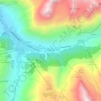
Name: Le Laisinant topographic map, elevation, terrain.
Average elevation: 2,254 m
Minimum elevation: 1,797 m
Maximum elevation: 2,966 m
Thank you for supporting this site ❤️
Make a donation
Make a donation
Other topographic maps
Click on a map to view its topography, its elevation and its terrain.
Glacier des Sources de l'Isère
France > Auvergne-Rhône-Alpes > Savoie > Val-d'Isère
Average elevation: 2,970 m
Réserve naturelle de la Bailletaz
France > Auvergne-Rhône-Alpes > Savoie > Val-d'Isère
Average elevation: 2,648 m